| Alaska state route ends photos
Below are photos of many of the endpoints of Alaska's twelve numbered state routes. For each route, I first provide (if available) a photo of the northern or western end, followed by one of the southern or eastern end. All of the following photos are my own, taken on my summer 1994, 2001, and 2007 vacations.
See also the parallel page with photos of the termini of all of Alaska's unsigned Interstates.
I have consulted the online route logs of the Alaska Department of Transportation and Public Facilities ("Alaska DOT&PF") to help identify the endpoints where (as is often the case) they are not readily discernable by "end" signs or otherwise.
NOTE: In case you want more detail, you can click any photo
below to view an enlarged, higher-quality (less .jpg compression) version.
Those alternate versions have larger file sizes, so please be patient while
they download. |
State route 1
(Tok Junction-Homer, via multiple highways)
|
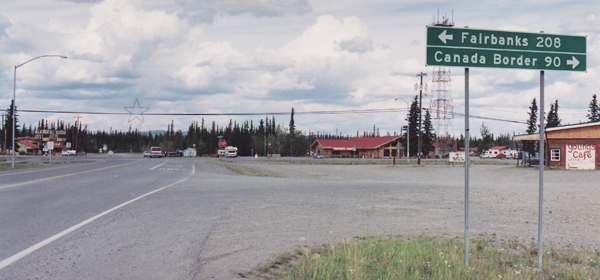
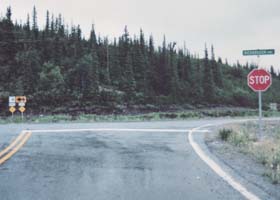
 In the background of this photo is the north end of state route 1 in Tok Junction, where the Tok Cutoff (northernmost segment of AK 1) intersects with the Alaska Highway (AK 2). (July 2001) In the background of this photo is the north end of state route 1 in Tok Junction, where the Tok Cutoff (northernmost segment of AK 1) intersects with the Alaska Highway (AK 2). (July 2001)
|
|
 |
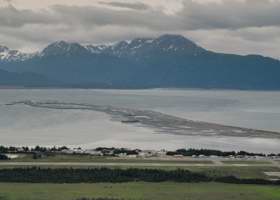 |
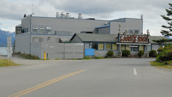
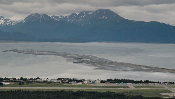
 State route 1 includes several different local roads in Homer, all of which are considered part of the Sterling Highway in state route logs. The southernmost segment, Homer Spit Road, ends at the Land's End Resort (above left). Homer Spit (above right, viewed from Skyline Drive high above downtown Homer) is a wide gravel bar sticking out into Kachemak Bay, and has shops, lodgings, the local harbor, and the Alaska Marine Highway terminal for ferry routes serving Seldovia, Kodiak, and the Aleutian chain. (Both photos August 2007) State route 1 includes several different local roads in Homer, all of which are considered part of the Sterling Highway in state route logs. The southernmost segment, Homer Spit Road, ends at the Land's End Resort (above left). Homer Spit (above right, viewed from Skyline Drive high above downtown Homer) is a wide gravel bar sticking out into Kachemak Bay, and has shops, lodgings, the local harbor, and the Alaska Marine Highway terminal for ferry routes serving Seldovia, Kodiak, and the Aleutian chain. (Both photos August 2007)
|
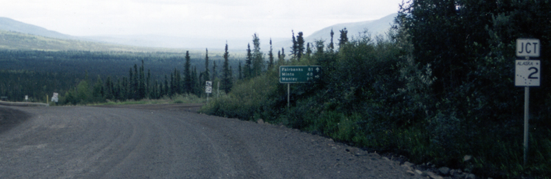
State route 2
(Manley Hot Springs-Canadian border, via the Elliott Highway, Steese Expressway, part of the Richardson Highway, and the Alaska Highway)
|
[No photo of west end]
|
 |
|
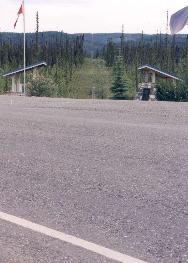
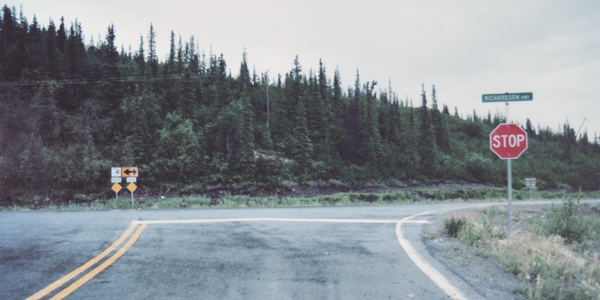
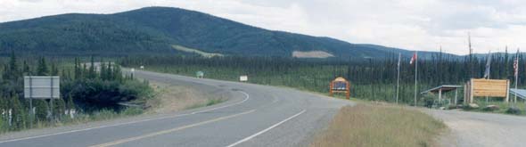
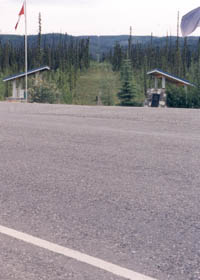
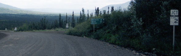
The east end of AK 2 is here, where the Alaska Highway crosses into Canada. In the photo above, facing eastbound, the
border crosses the highway diagonally, from a few feet on the other side
of the sign on the left, through the exhibits and flags on the other side
of the road. The photo to the right was taken on the border, facing south
across the highway, to show the swath of clearcut through the forest which
marks much of the international border between Alaska and the Yukon. (Both photos June 2001)
Both customshouses are set back from the border, with U.S. customs
0.3 miles to the west, and Canadian customs in Beaver Creek, Yukon Territory,
about 20 miles to the southeast. |
 |
State route 3
(Fairbanks-Palmer, Mitchell Expressway and Parks Highway)
|
 |
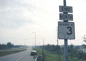 |
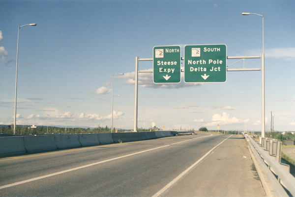
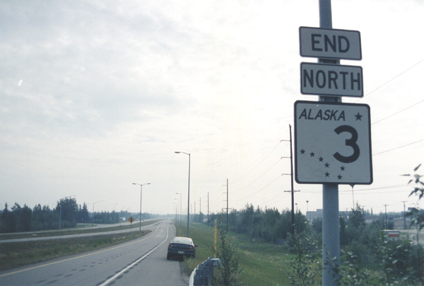
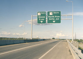
Two photos
of the north end of Alaska state route 3, at the interchange with
Alaska state route 2. The photo on the left is on AK 3 northbound just
before the northbound and southbound exit ramps diverge. (No, the exit
sign isn't telling you to go south to the North Pole; "North Pole" is a
heavily Christmas-themed suburb a few miles southeast of Fairbanks.) On
the right is the "end" sign on the ramp from AK 3 northbound to AK 2 southbound. (Both photos June 2001)
|
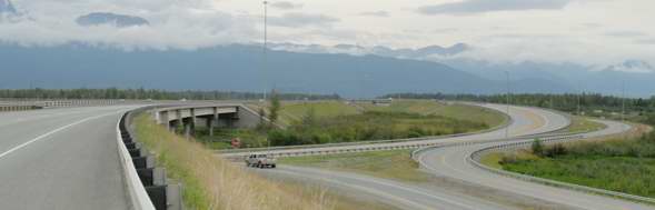 |
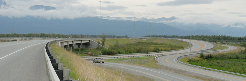
| The south end of Alaska state route 3, at its complex interchange with Alaska state route 1 (Glenn Highway) near Palmer. Alaska DOT&PF upgraded this junction in 2004. The through lanes on the left take traffic directly from the Parks Highway southbound to the Glenn Highway westbound. The official end of AK 3 and the Parks Highway is at the beginning of the bridge on the left, which carries the through lanes over the Glenn Highway (there is no "end" sign southbound, but on the other side of that bridge, there is a "begin" sign confirming the change in state route number). In the center is the ramp from the southbound Parks Highway to the eastbound Glenn Highway toward Palmer. To the right of that ramp is a frontage road. In the distant background is the bridge carrying eastbound Glenn Highway traffic over the through lanes to the northbound Parks Highway, so eastbound Glenn Highway traffic exits and crosses over the freeway, then curls back under the freeway to continue to
Palmer. (July 2007) |
State route 4
(Delta Junction-Valdez, part of Richardson Highway)
|
 |
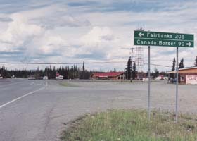
Here in Delta Junction, the northbound lanes of the Richardson Highway continue through the intersection, with Alaska Highway (part of state route 2) traffic merging from the right. The Richardson Highway keeps going to Fairbanks, but as part of state route 2 rather than as route 4. Abundant signage in Delta Junction reminds motorists that the Alaska Highway ends here, rather than in Fairbanks. (July 2001)
|
[No photos of south end]
|
State route 5
(Eagle-Tetlin Junction, Taylor Highway)
|
[No photo of north end]
|
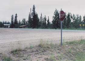
The Taylor Highway's southern end, at the intersection with the Alaska Highway (state route 2), in Tetlin Junction a few miles east of Tok Junction. This photo was taken when the south end of the Taylor Highway was unpaved; I understand that it now is paved. (July 2001)
|
|
State route 6
(Fox-Circle, Steese Highway)
|
|
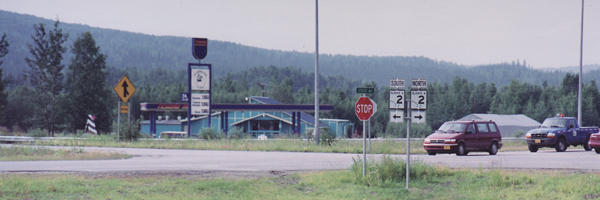
 The west end of state route 6 is here in Fox, at the junction of the Steese Highway with state route 2, the Elliott Highway to the right and the Steese Expressway to the left. This photo was taken from a truck weigh station at the northeast corner of the intersection. Straight ahead through the intersection is Old Steese Highway continuing south to Fairbanks, parallel to the expressway that replaced it. (July 2001) The west end of state route 6 is here in Fox, at the junction of the Steese Highway with state route 2, the Elliott Highway to the right and the Steese Expressway to the left. This photo was taken from a truck weigh station at the northeast corner of the intersection. Straight ahead through the intersection is Old Steese Highway continuing south to Fairbanks, parallel to the expressway that replaced it. (July 2001)
|
 |
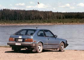 |
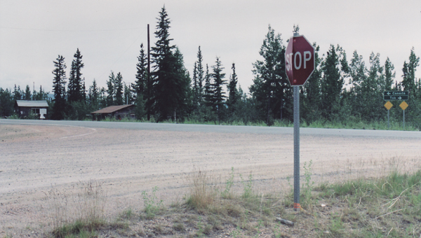
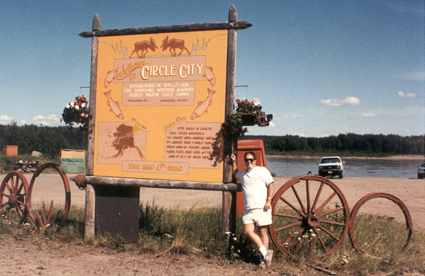
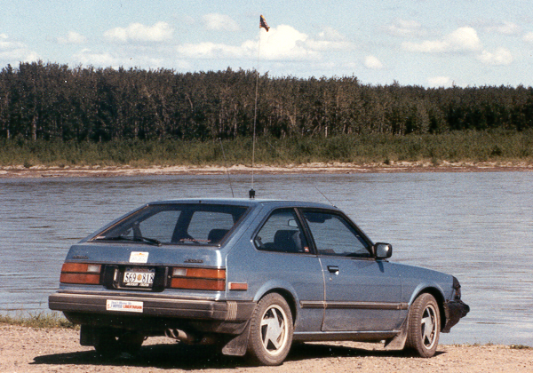
The sign above left, with me standing next to it, marks the east end of the Steese Highway, on the south bank of the Yukon River in Circle (so named in the mistaken belief it was on the Arctic Circle). The photo above right is of my old 1982 Honda Accord, parked along the river just past the end of the highway. (Both photos July 1994)
|
State route 7
(Canadian border-Ketchikan, via multiple highways and ferry segments)
|
[No photos of either end]
|
State route 8
(Cantwell-Paxson, Denali Highway)
|
[No photo of west end]
|
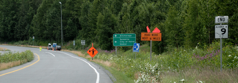
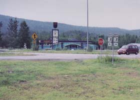
The Denali Highway's eastern end is in Paxson, here at the intersection with the Richardson Highway (state route 4). (July 2001)
|
|
State route 9
(Tern Lake Junction-Seward, part of Seward Highway)
|
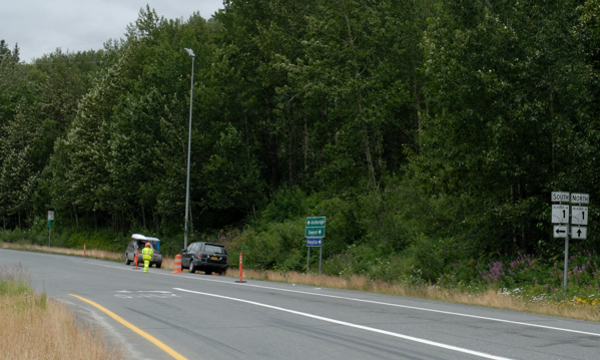
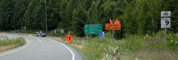 |
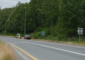
The junction of the state route 9 segment of the Seward Highway with state route 1 is at this junction (overview in above photo, closeup in photo to the right), next to Tern Lake in the central Kenai Peninsula. The Seward Highway continues straight through the intersection as part of state route 1; a left turn takes you on the Sterling Highway segment of state route 1. (Both photos August 2007)
|
|
|
The southbound Seward Highway (at this point 3rd Avenue) ends here in downtown Seward, at the intersection with Railway Avenue. (August 2007)
|
State route 10 (northern segment)
(Copper Center-Chitina, Edgerton Highway)
|
[No photos of either end]
|
State route 10 (southern segment)
(Cordova-Million Dollar Bridge, Copper River Highway)
|
[No current photos of either end; see Million Dollar Bridge photos page for photos of east end before the bridge was repaired]
|
State route 11
(Deadhorse-Livengood, Dalton Highway)
|
[No photo of north end]
|
 |
| This is the
south end of the Dalton Highway, facing southbound, where it joins AK 2 (Elliott Highway) near Livengood. Most southbound
Dalton Highway traffic goes straight ahead onto the eastbound Elliott Highway
to Fairbanks. A right turn takes you west on the Elliott Highway, to Manley Hot Springs. (June 2001) |
State route 98
(Canadian border-Skagway, Klondike Highway)
|
[No photos of either end]
|
Alaska Roads main page (under construction as of October 2007, but has some useful information and links)
Questions, comments? Please e-mail me.
© Oscar Voss 1994, 2001-2002, 2004, 2007. |