| Alaska Interstate ends photos
All of the following photos are my own, taken on my summer 2001 and 2007 vacations.
Alaska's four Interstates (A-1, A-2, A-3,
and A-4) are completely unsigned. (The route numbers
were originally approved without hyphens, as A1, A2, etc., but lately the
Federal Highway Administration has been using hyphens in its route lists
and other documents mentioning Alaska's Interstates, so I'll go with that.)
As you can see below, Alaska's Interstates are not required to meet
conventional Interstate standards (unlike the Interstates in the lower
48 and Hawaii), per Federal legislation enacted in 1980 which also let
Puerto Rico get its own set of "paper Interstates." Indeed, almost all
of Alaska's Interstate mileage is two-lane undivided highway with at-grade
crossings, rather than Interstate-standard multilane divided controlled-access
highway (though some of the Interstate mileage around Anchorage seems to
meet or come close to normal Interstate standards).
I have consulted historical records relating to the designation of
Alaska's Interstates, from the Alaska Department of Transportation and
Public Facilities ("Alaska DOT&PF"), and also the American Association
of State Highway and Transportation Officials, to identify the endpoints
shown below.
NOTE: In case you want more detail, you can click any photo
below to view an enlarged, higher-quality (less .jpg compression) version.
Those alternate versions have larger file sizes, so please be patient while
they download. |
Interstate A-1
(Anchorage-Canadian border, via parts of state routes 1 and 2)
|
|
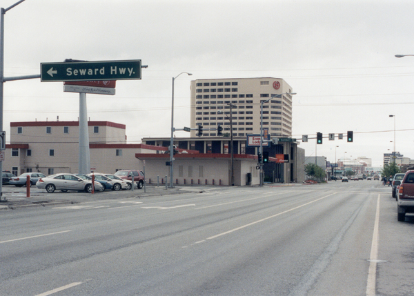
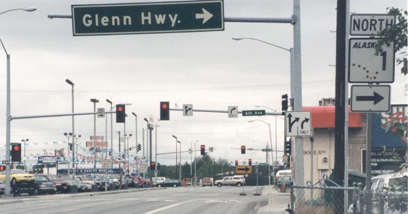
 Interstate
A-1's west end is here in downtown Anchorage. This photo was taken from
5th Street (one-way, Interstate A-1 and Alaska 1 westbound) just east
of its intersection with Gambell Street (one-way, Interstate A-3 southbound
and Alaska 1 continuing southbound to the Seward Highway). Interstate
A-1's west end is here in downtown Anchorage. This photo was taken from
5th Street (one-way, Interstate A-1 and Alaska 1 westbound) just east
of its intersection with Gambell Street (one-way, Interstate A-3 southbound
and Alaska 1 continuing southbound to the Seward Highway). |
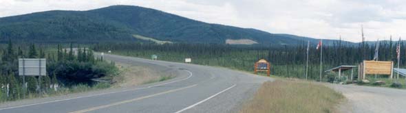 |
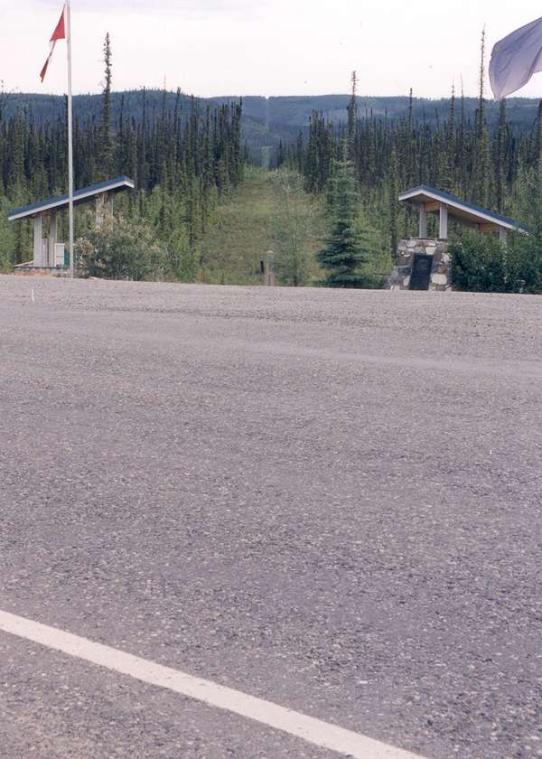
  The east end of Interstate A-1 is here, where the Alaska Highway (Alaska
2/Yukon 1) crosses into Canada. In the photo above, facing eastbound, the
border crosses the highway diagonally, from a few feet on the other side
of the sign on the left, through the exhibits and flags on the other side
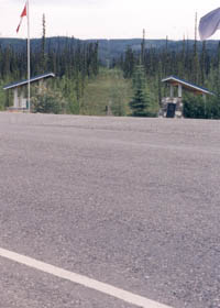
of the road. The photo to the right was taken on the border, facing south
across the highway, to show the swath of clearcut through the forest which
marks much of the international border between Alaska and the Yukon.
The east end of Interstate A-1 is here, where the Alaska Highway (Alaska
2/Yukon 1) crosses into Canada. In the photo above, facing eastbound, the
border crosses the highway diagonally, from a few feet on the other side
of the sign on the left, through the exhibits and flags on the other side
of the road. The photo to the right was taken on the border, facing south
across the highway, to show the swath of clearcut through the forest which
marks much of the international border between Alaska and the Yukon.
Both customshouses are set back from the border, with U.S. customs
0.3 miles to the west, and Canadian customs in Beaver Creek, Yukon Territory,
about 20 miles to the southeast. |
 |
Interstate A-2
(Fairbanks-Tok Junction, via part of state route 2)
|
 |
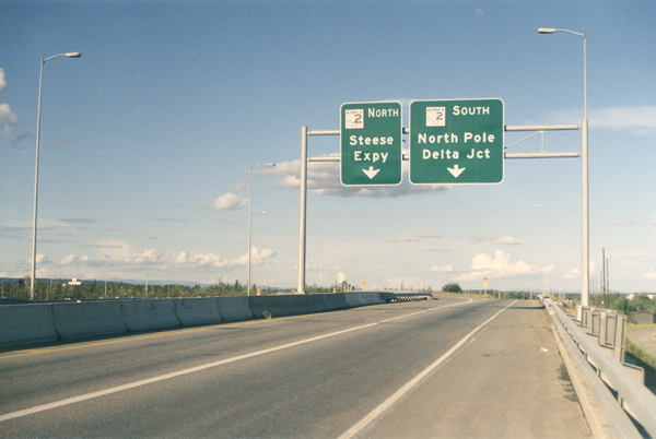
| This is the
interchange at the north end of the Richardson Highway in Fairbanks, where
Interstate A-2/Alaska 2 northbound joins the Mitchell Expressway westbound
(part of Interstate A-4/Alaska 3 southbound). Alaska 2 continues past the
interchange (under the overpass barely visible near the left edge of the
photo) as the Steese Expressway bypass through east Fairbanks, then as
the Elliot Highway to Manley Hot Springs.
Note: An old Alaska DOT&PF map suggested that A-2 may technically still end about a mile north of this
junction, at the intersection of the Steese Expressway and Airport
Way, where A-4 (Alaska 3) used to end before it was rerouted to the Mitchell
Expressway. I do not have any photos of that intersection. However, other sources (including Alaska DOT&PF's most recent online route log for the Richardson Highway) confirm that A-2's current end is at the junction shown above, specifically at the northbound exit ramp to the Mitchell Expressway.
|
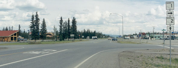 |
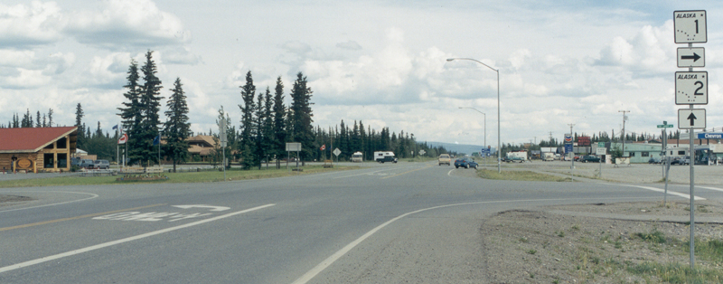
| Tok Junction,
from the southbound Alaska Highway (Alaska 2, continuing through the intersection)
where it meets the Tok Cut-off (north end of Alaska 1) turning back toward
Anchorage. Interstate A-2 ends here; Interstate A-1 follows the rest of
the Alaska Highway, from the international border to this intersection,
then continues west on the Tok Cut-off. |
Interstate A-3
(Anchorage-Soldotna, via part of state route 1)
|
 |
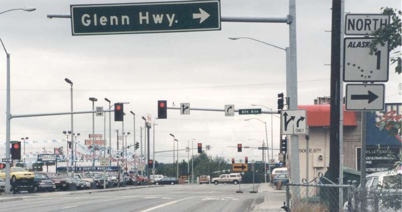
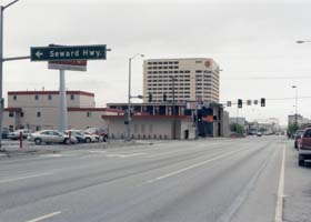
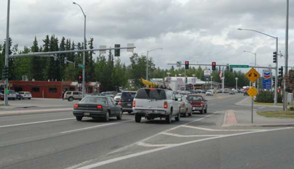
Interstate
A-3's north end is here in downtown Anchorage. This photo was taken from
Ingra Street (one-way, Interstate A-3 and Alaska 1 northbound) just south
of its intersection with 6th Avenue (one-way eastbound, Interstate A-1
and Alaska 1 continuing to the Glenn Highway).
|
 |
| The south
end of Interstate A-3 is here in Soldotna on the Kenai Peninsula. This August
2007 photo is from Sterling Highway (Interstate A-3 southbound to this point,
and also Alaska 1 southbound continuing beyond the intersection) where
it intersects with unnumbered Kenai Spur Highway branching off to the right. |
Interstate A-4
(Fairbanks-Palmer, via state route 3)
|
 |
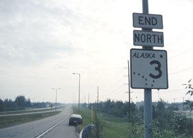 |
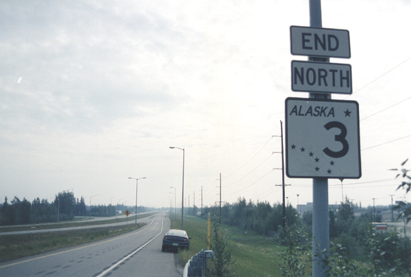
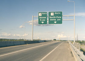
Two photos
of the north end of Interstate A-4 (Alaska 3), at the interchange with
Interstate A-2/Alaska 2. The photo on the left is on A-4 northbound just
before the northbound and southbound exit ramps diverge. (No, the exit
sign isn't telling you to go south to the North Pole; "North Pole" is a
heavily Christmas-themed suburb a few miles southeast of Fairbanks.) On
the right is the Alaska 3 "end" sign on the ramp from A-4 northbound to
A-2 southbound.
|
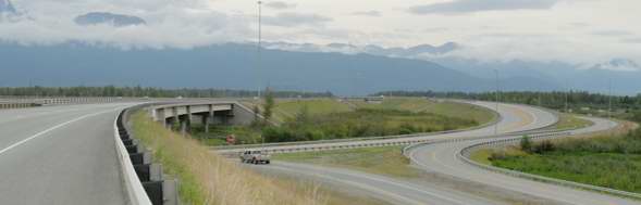 |
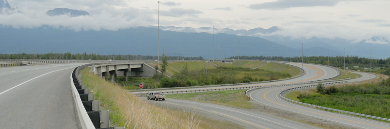
| The south end of Interstate A-4 (Alaska 3, Parks Highway), at its complex interchange with Interstate A-1 (Alaska 1, Glenn Highway) near Palmer, in July 2007. Alaska DOT&PF upgraded this junction in 2004. The through lanes on the left take traffic directly from the Parks Highway southbound to the Glenn Highway westbound. The official end of Interstate A-4 (and Alaska 3 and the Parks Highway) is at the beginning of the bridge on the left, which carries the through lanes over the Glenn Highway (there is no "end" sign southbound, but on the other side of that bridge, there is a "begin" sign confirming the change in state route number). In the center is the ramp from the southbound Parks Highway to the eastbound Glenn Highway toward Palmer. To the right of that ramp is a frontage road. In the distant background is the bridge carrying eastbound Glenn Highway traffic over the through lanes to the northbound Parks Highway (so eastbound Glenn Highway traffic exits and crosses over the freeway, then curls back under the freeway to continue to Palmer). |
Alaska Roads main page (still under construction as of October 2007, but has some useful information and links)
Questions, comments? Please e-mail me.
© Oscar Voss 2001-2002, 2004, 2007. |